

When you look at the Western Hemisphere on a world map, you will find Haiti positioned about 50 miles southeast of Cuba and about 700 to 800 miles southeast of Florida, the United States. Haiti is located on an island of the Caribbean Sea called Hispaniola, which is part of the Greater Antilles islands. These islands consist of Hispaniola, Cuba, Jamaica, the Cayman Islands and Puerto Rico.
Hispaniola contains two countries. Haiti makes up the western portion of the island, while the Dominican Republic makes up the eastern portion. Haiti is estimated to consume roughly three-eighths of the island, which leaves the Dominican Republic with the other five-eighths. The two countries share a border with each other that is 224 miles long (360 kilometers).
Haiti is shaped like a horseshoe and contains several coastal beaches, towns, and smaller offshore islands. The entire landmass of Haiti is approximately 10,714 square miles (or 27,750 square kilometers). The coastline is obviously disproportionately shaped but it adds up to approximately 1,100 miles (1,771 kilometers) in length. The other only Caribbean country with a longer coastline is Cuba, which is also the biggest island country in the Caribbean as well.
Haiti has a rich and diverse landscape. You’ll find almost every tropical terrain type there. Aside from the white sandy beaches along the coastline, you’ll find mountains, river valleys and grassy plains as you go inland. You can see the mountainous areas quite clearly if you look at a topographical map of Haiti. It shows the mountain ranges running all along the central areas of the horseshoe shaped countryside.
Did you know the word “Haiti” is the Indian word for “mountains?” It was the name given to the country after its former African slaves achieved independence from France in 1804. Since 80% of Haiti has an elevation greater than 600 feet, the name is perfectly suitable for it. In fact, Pic la Selle is the tallest mountain in Haiti and it has an elevation of up to 9,000 feet.
The Massif du Nord is Haiti’s lengthiest mountain range. It is located in the northern region of the country, but it connects with a lengthy mountain range in the Dominican Republic called the Cordillera Central. The mountain range flows right through the eastern border in which Haiti shares with the Dominican Republic. Just north of the border is the Guayamouc River, which is one of the main rivers in Haiti.
Offshore Islands
There is more to Haiti than its large horseshoe landscape on the eastern side of Hispaniola island. Inside the waters of the horseshoe, Haiti owns several islands within the waters of the Caribbean Sea. For instance, just off the northern coast of Haiti is an island called Tortuga. The size of the island is 69 square miles (180 square kilometers) and has an estimated population of about 30,000 people.
Tortuga is historically significant regarding the piracy that used to take place in the Caribbean during the 17th century. Evidence suggests that most of the Caribbean piracy activities took place on and around the island of Tortuga. Modern Haiti has turned the island into a tourist attraction by showing works and references to the “pirates of the Caribbean” of that time.
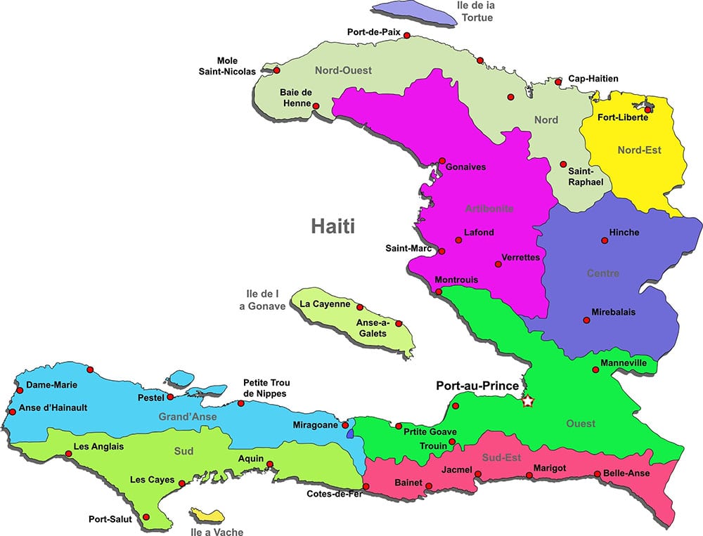
The largest offshore Haitian island is La Gonâve Island. It is located to the west of Port-au-Prince, which is the capital city of Haiti. The water between the horseshoe arms of Haiti is called the Gulf of La Gonâve. That is where La Gonâve Island lies. In fact, the entire island is an arrondissement of one of the ten national Haitian departments. This particular department is called the Ouest, which features the communes of Pointe-a-Raquette and Anse-a-Galets.
If you look southwest from the coast of Haiti, you’ll find a third big island called Île-à-Vache. The translation of Île-à-Vache is “Cow Island.” It is known as a tourist island because it offers some of the best picturesque views in all of the Caribbean. Back in the 1800s, farmers used the island for raising livestock, including cows. That is likely how the island got its name.
African Association
Most of the Haitian people living today are descendants of African slaves. A small percentage of Haiti’s population has some European ancestry due to the European colonists and slaves having children together. These mixed-race children were called mulattoes.
Westerners like to refer to Haitians as Africans because of their close ancestral links. But it is important to note that Haiti is not an African country nor is it part of the African continent. However, in February 2012, the Haitian government submitted a request to become a full associate member of the African Union. Right now, Haiti only has observer member status, so an upgrade to associate status would be symbolic.
During the African Union 2013 Summit, the union had reportedly planned to approve Haiti’s application to upgrade their status. Unfortunately, the African Union ultimately decided against allowing Haiti to join their union because it is not an African State. The only way any country can join the African Union is if it is actually part of the African continent.
Therefore, Haiti will continue to remain as a Caribbean nation on the map and on legislation. They wanted to join the African Union due to the African roots of the Haitian people. If their application had been approved to join the union, it would have brought more security, development and economic prosperity to the Haitian people. But now, once again, the Haitians must continue to depend on the United States for all foreign aid and assistance.